The Wiki for Tale 4 is in read-only mode and is available for archival and reference purposes only. Please visit the current Tale 11 Wiki in the meantime.
If you have any issues with this Wiki, please post in #wiki-editing on Discord or contact Brad in-game.
Difference between revisions of "Atlas"
From A Tale in the Desert
Jump to navigationJump to search| Line 1: | Line 1: | ||
The new mapping system is in place and working. Read the [[Google Maps|documentation]] if you don't know how to use the new maps, and please add to the Atlas if you do. | The new mapping system is in place and working. Read the [[Google Maps|documentation]] if you don't know how to use the new maps, and please add to the Atlas if you do. | ||
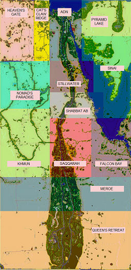
| − | <googlemap> | + | [[Image:Regions.jpg | 256px | thumb | Map with Region names]] |
| + | <googlemap lat=1010 lon=0 zoom=1 width=512 height=512> | ||
</googlemap> | </googlemap> | ||
==Regions== | ==Regions== | ||
| − | |||
| − | |||
| − | |||
*[[Adn]] (Formerly Lower Egypt) | *[[Adn]] (Formerly Lower Egypt) | ||
*[[Cat's Claw Ridge]] (Formerly Qatara) | *[[Cat's Claw Ridge]] (Formerly Qatara) | ||
| Line 36: | Line 34: | ||
===Resources=== | ===Resources=== | ||
| − | *[[Map of Resources]] | + | *[[Map of Rare Resources]] |
| + | *[[Map of Limestone]] | ||
| − | + | ===Landmarks=== | |
| − | |||
| − | |||
| − | |||
| − | |||
| − | |||
| − | |||
| − | |||
| − | === | ||
*[[Mountains]] | *[[Mountains]] | ||
| + | *[[Statues]] | ||
==Public Facilities== | ==Public Facilities== | ||
| + | *[[Map of Public Facilities]] | ||
===Adn=== | ===Adn=== | ||
| − | *[[Guilds/CCHC| Crouching Camel, Hidden Cicada]] | + | *[[Guilds/CCHC| Crouching Camel, Hidden Cicada]] |
| − | *[[Guilds/PBPW| | + | *[[Guilds/PBPW| PI Bridge Public Works Board]] |
===Cat's Claw Ridge=== | ===Cat's Claw Ridge=== | ||
| Line 59: | Line 52: | ||
===Falcon Bay=== | ===Falcon Bay=== | ||
| − | *[[Guilds/FBRAII|Falcon Bay Research and Industry Institute | + | *[[Guilds/FBRAII|Falcon Bay Research and Industry Institute]] |
===Heaven's Gate=== | ===Heaven's Gate=== | ||
| Line 68: | Line 61: | ||
===Meroe=== | ===Meroe=== | ||
| − | *[[Guilds/Meroe_Public_Works|Meroe Public Works]] | + | *[[Guilds/Meroe_Public_Works|Meroe Public Works]] |
| − | |||
| − | |||
| − | |||
| − | |||
| − | |||
===Nomad's Paradise=== | ===Nomad's Paradise=== | ||
Revision as of 17:18, 20 December 2008
The new mapping system is in place and working. Read the documentation if you don't know how to use the new maps, and please add to the Atlas if you do.
Regions
- Adn (Formerly Lower Egypt)
- Cat's Claw Ridge (Formerly Qatara)
- Falcon Bay (Formerly Cradle of the Sun)
- Heaven's Gate (Formerly Valley of the Kings)
- Khmun (Formerly Fool's Paradise)
- Meroe (Formerly Kush)
- Nomad's Paradise (Formerly Desert of Shades)
- Pyramid Lake (Formerly Tanis)
- Queen's Retreat (Formerly Khartoum)
- Saqqarah (Formerly Karnak)
- Shabbat Ab (Formerly Seven Lakes)
- Sinai
- Stillwater (Formerly Upper Egypt)
Locations
Education
Travel
Test Related
Resources
Landmarks
Public Facilities
Adn
Cat's Claw Ridge
- Rock saw and pottery wheels - Cat's Claw Ridge -552, 6830
Falcon Bay
Heaven's Gate
- Pottery Wheels - Heaven's Gate -1627, 8068
Khmun
Meroe
Nomad's Paradise
Pyramid Lake
Queen's Retreat
Saqqarah
Shabbat Ab
Sinai
Stillwater
- Flax Hammock - Stillwater 1089, 3543 (Highest Peak)
