The Wiki for Tale 5 is in read-only mode and is available for archival and reference purposes only. Please visit the current Tale 11 Wiki in the meantime.
If you have any issues with this Wiki, please post in #wiki-editing on Discord or contact Brad in-game.
Difference between revisions of "Atlas"
(→Map) |
(→Locations: updated for consistency and to be in line with shard policy) |
||
| Line 78: | Line 78: | ||
== Locations == | == Locations == | ||
| − | === | + | === Egypt-wide === |
| − | + | * [[Atlas/Amunet/Limestone|Map of limestone locations]] | |
| − | + | * [[Maps/Expedition Sites|Map of Expedition Site locations]] | |
| − | + | * [[Atlas/Amunet/Humble_Priests_Alter|Map of Humble Priests' Alter locations]] | |
| − | |||
===Alcyone=== | ===Alcyone=== | ||
| − | *[[Region/Amunet/Alcyone|Alcyone | + | *[[Region/Amunet/Alcyone|Alcyone Regional Atlas]] |
===Celaeno=== | ===Celaeno=== | ||
| Line 91: | Line 90: | ||
===Maia=== | ===Maia=== | ||
| − | * [[Region/Amunet/Maia|Maia | + | * [[Region/Amunet/Maia|Maia Regional Atlas]] |
===Sinai=== | ===Sinai=== | ||
| Line 97: | Line 96: | ||
===Sterope=== | ===Sterope=== | ||
| − | * [[Atlas/Sterope|Sterope | + | * [[Atlas/Sterope|Sterope Regional Atlas]] |
* [[Region/Amunet/Sterope#Public_Use_Buildings|Sterope Public Faculities listing]] | * [[Region/Amunet/Sterope#Public_Use_Buildings|Sterope Public Faculities listing]] | ||
===Taygete=== | ===Taygete=== | ||
| − | * [[Atlas/Taygete|Central Taygete | + | * [[Atlas/Taygete|Central Taygete zoomed-in PNG]] |
* [[Region/Amunet/Taygete#Public_Buildings|Taygete Public Works and Mining Camps]] | * [[Region/Amunet/Taygete#Public_Buildings|Taygete Public Works and Mining Camps]] | ||
Revision as of 16:28, 28 September 2010
This Atlas gives information about ATITD's regions, natural features and human creations of note.
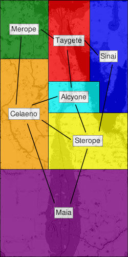
Regions and Boundaries
The seven regions of Egypt are, with the exception of Sinai, named for the seven sisters of the Pleiades from Greek mythology (fittingly, the daughters of Atlas).
| Region | North | South | West | East | Chariot Stop |
|---|---|---|---|---|---|
| Alcyone | 3000 | 1000 | 11 | 3300 | 1740, 2313 |
| Celaeno | 4459 | -2600 | -3070 | 10 | -1717, 832 |
| Maia | -2600 | -8200 | -3070 | 5120 | 968, -5595 |
| Merope | 8200 | 4450 | -3070 | 10 | -1609, 7628 |
| Sinai | 8200 | 1000 | 2000 | 5125 | 2735, 5012 |
| Sterope | 1000 | -2600 | 11 | 5120 | 1995, -2012 |
| Taygete | 8200 | 3000 | 11 | 2001 | 885, 6036 |
Map
This map uses the CondMap template and should not be edited directly. Please see Maps for further details and links to all raw data pages
Chariot Routes
See Chariot Routes
Locations
Egypt-wide
Alcyone
Celaeno
Maia
Sinai
Sterope
Taygete
Resources
Public Mines
Gathered Resources
Gem Types
   * Quartz - Sterope (public sand mine)
   * Ruby - Maia (public sand mine)
   * Topaz - Alcyone (public sand mine)
   * Emerald - Celaeno (public sand mine)
   * Sapphire - Merope (public sand mine)
   * Diamond - Sinai (public sand mine)
   * Opal - Taygete (public sand mine)
Test Related
Here is a high resolution map of Egypt (T5A Shard). WARNING: This is a 29MB PNG; it's not recommended to look at this in a browser as you may go blind.
