The Wiki for Tale 5 is in read-only mode and is available for archival and reference purposes only. Please visit the current Tale 11 Wiki in the meantime.
If you have any issues with this Wiki, please post in #wiki-editing on Discord or contact Brad in-game.
Difference between revisions of "Atlas"
From ATITD5
Jump to navigationJump to search (→Map) |
(→Map) |
||
| Line 17: | Line 17: | ||
(PuT) 1504,4329, Tar at Taygete 1504,4329 | (PuT) 1504,4329, Tar at Taygete 1504,4329 | ||
(PuT) -1901,1853, Tar at Celaeno -1901,1853 | (PuT) -1901,1853, Tar at Celaeno -1901,1853 | ||
| + | (PuT) 58,1286, Tar at Aicyone 58 1286 | ||
(YeS) 10000,0 Sulphurous Water | (YeS) 10000,0 Sulphurous Water | ||
Revision as of 13:07, 9 August 2010
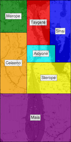
This Atlas gives information about ATITD's regions, natural features and human creations of note.
Map
Regions and Boundaries
| Region | North | South | West | East | Chariot Stop |
|---|---|---|---|---|---|
| Aicyone | 3000 | 1000 | 11 | 3300 | |
| Celaeno | 4459 | -2600 | -3070 | 10 | |
| Maia | -2600 | -8200 | -3070 | 5120 | ~970 -5593 |
| Merope | 8200 | 4450 | -3070 | 10 | |
| Sinai | 8200 | 1000 | 2681 | 5125 | |
| Sterope | 1000 | -2600 | 11 | 5120 | 1995, -2012 |
| Taygete | 8200 | 3000 | 11 | 2680 |
Locations
Amunet
Resources
Here is a high resolution map of Egypt (T5A Shard). WARNING: This is a 29MB PNG; it's not recommended to look at this in a browser.
